When viewed from Earth. The most prominent identity of Mars is Poles and covered with a white pole will shrink down when the summer on Mars And larger when the winter. The surface is quite dense darkness of this planet is the season of change identity. Which saw itself as this That astronomer G. Schiaparelli name on more than 130 years ago to think that Mars is a living creature. Because he claimed he saw canali that have caused a lot of digging by humans.
However, manned space, such as motor Mariner to explore Mars when thirty years ago has shown the world that no canals anywhere on Mars, imagination and ideas, personal and concentrate on the idea that a man on Mars Can make people panic around the world. This event shows that we need to use the scientific process. Physics to prove them true.
(Image map solar system, Mars will lay away from the sun Backpacks No. 4 next to our world).
Mars is thin and the atmosphere is carbon dioxide. Surface similar to craters on the Moon similar to the volcanic mountains and deserts and polar ice on the ground. Surface of Mars as the sea. With large rocks and deep holes, a high mountain valley and hills catch many Mars is the highest mountain in the solar system is Olympus Mount and Marineris canyon called the largest in the solar system. One year on Mars is almost two years as the world. But one day on Mars longer than a half hour the world a little. Mars air shroud is not so much. Mars is about half of the larger world. (Picture the highest mountain in the solar system, Mars is the Olympus Mount) diameter crater's mouth, a. 624 km (374 miles) is equal to the size of Arizona, USA July 25 km high.
Since 2006, NASA has been exploring Mars by sending motor Mars Reconnaissance. Orbiter orbit above the surface of Mars, 300 km (187 miles) on the Mars. Reconnaissance Orbiter Camera has a very high performance is to record images of objects as small as a soccer ball) and can identify basic definition of advanced image called HiRISE. (Picture above orbiting Mars Reconnaissance Orbiter imaging Mars).
And photographs of the actual following of Mars from the Mars Reconnaissance Orbiter has detailed the nature of the terrain surface of Mars Neighboring planets of our world. View photos and try to imagine the cold, dry extremes. A distance away from these images. ---- Look at the sand dunes on Mars, dust deposition thick and thin. Contrast with the sand dunes is a strange pattern. , The slope of the green rolling sand dunes along the edge.
Image is eroded crater on Mars called Pavonis Mons was found on a large flat area on Mars The surface of the terrain like scalloped.
Part of blue sand dunes in the area known as The Abalos Undae of Mars, the blue wave that appears as a line due to the composition of Ba Salt Rock. Lighter than the dust.
The Martian South Polar Cap to terrain valley floors have stains appear due process of sublimation sublimation for a long time then leaving the rest.
The Martian South Polar Cap is the characteristic class of minerals. From the vertical cliffs to the long silvery light. Leaching and erosion caused by wind action organizations. Shaped like a V.
In the canyon area called the Valley Marineris, the largest in the solar system.
In the canyon area called the Valley Marineris, the largest in the solar system.
Marineris on Mars, which is the largest valley in the solar system extending more than 4,000 KM, 200 KM wide and deeper than 7 KM.
North Pole giant glaciers on the steep cliffs of Mars caused by a combination of dust and ice is a big block. From the ice to see some hair is down from towering cliffs to the bottom like a cloud.
Areas that have caused flooding in the ancient past of Mars called Ares and Tiu and the robotic exploration of Mars for NASA. The robot consists of a wheel on NASA's Mars Exploration Rover Sojourner in a Mars Pathfinder Mission ever landing on Mars on 4 July 1997 and is operating to work on 27 Sep the same year.
Victoria Crater.
Polygons formed Linear dunes at the north polar region of Mars from the assumption that the action of ice.
Shaped dunes Scalloped sand dunes in the southern hemisphere of mars, which happens to be a normal seasonal by the action of ice on Mars.
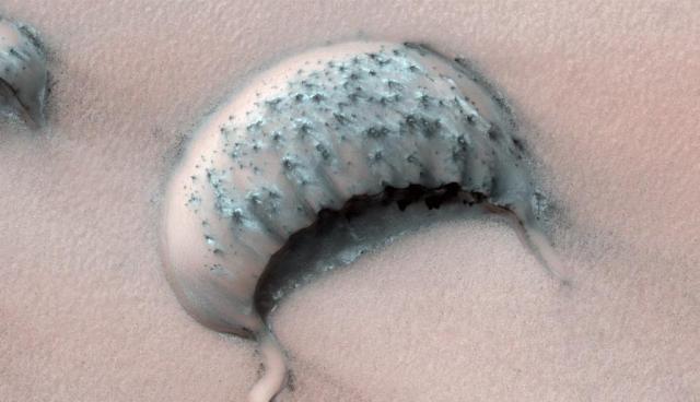
A large sand dune called barchan type on Mars over time, many years to shrink. Shaped like a crescent moon.
http://marsrovers.jpl.nasa.gov/newsroom/pressreleases/20110411a.html
http://en.wikipedia.org/wiki/Mars
http://mars.jpl.nasa.gov/gallery/atlas/olympus-mons.html
http://www.aerospaceguide.net/mars/reconnaissance_orbiter.html
http://en.wikipedia.org/wiki/Valles_Marineris
http://www.boston.com/bigpicture/2009/11/martian_landscapes.html
http://wanderingspace.net/2006/12/


No comments:
Post a Comment